Madison County Atlases
Collection Owner:
Cover Image:

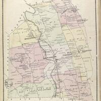
Atlas of Madison Co. New York, page 13 - Image Source
Collection Facts
Extent:
1
Dates of Original:
1875
Additional Information
Scope and Content Source:
Browse similar collections
NYH Topic Areas:
Collection Type: